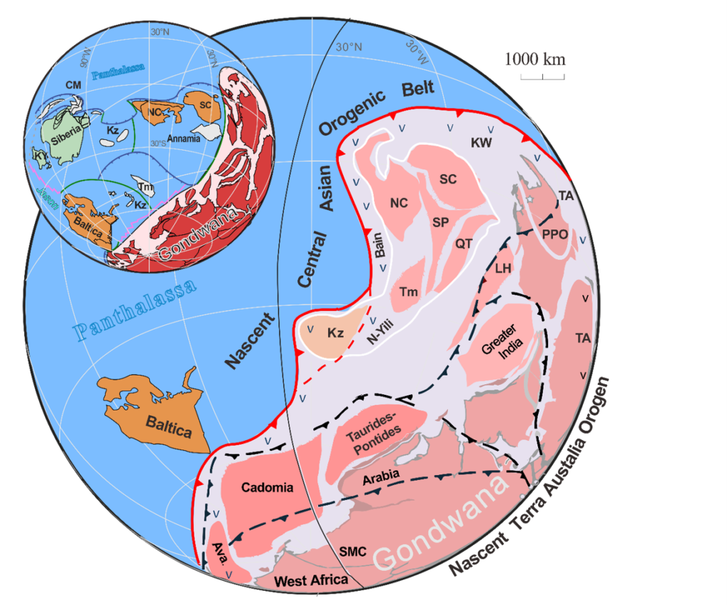
A new study published on Wednesday in Science Advances has confirmed that Gondwana was a true supercontinent, accounting for roughly 80 percent of Earth’s landmass between 550 and 500 million years ago.
This finding corrects the long-held view that the massive landmass in the Southern Hemisphere only covered two-thirds of the planet’s surface at the time. The research, led by Tao Wang of the Chinese Academy of Geological Sciences, rewrites the geological timeline surrounding the Cambrian explosion.
The size of Gondwana
The team gathered over 25,000 rock samples from ancient continental fragments. By analysing these, they revealed that Gondwana’s physical footprint was far larger than previously thought. This expansion of land area is now linked directly to the rapid proliferation of complex life that began about 538 million years ago.
William Collins, a professor of geosciences at Curtin University and an author on the study, described the discovery as serendipitous. He told 404 Media that the researchers were not looking for the supercontinent specifically.
Wang noted that the team’s database is still growing. “If we expand our database, maybe we will have new, unexpected results,” he said.
How the map was built
Wang has spent much of his career studying the Central Asian Orogenic Belt. This region stretches from Russia’s Ural Mountains across Asia to the Pacific Ocean. It is shaped by the collision of continental plates.
In recent years, his team assembled a database of thousands of magmatic rocks from this region and others. They worked as part of an international collaboration called Deep-time Digital Earth. Using AI combined with new techniques, the researchers identified the origins of many samples for the first time.
This allowed them to place the rocks into a global map used to reconstruct continents from the deep past. “We used special techniques to get coordinates and locations,” Wang said. “In this way, we expanded our research from Asia to globally.”
Collins explained the process: “If you collect enough data, you can then map out where these ancient crustal blocks were. This is how we came across this new map of the Earth—this deep crustal map extending back 500—and more—million years ago.”
Isotopic fingerprints
The global map revealed disparate chunks of Gondwana broken apart by eons of tectonic activity. The team focused on isotopes of the elements samarium and neodymium. Collins described these as “fingerprints” of the lost supercontinent embedded inside much younger rocks.
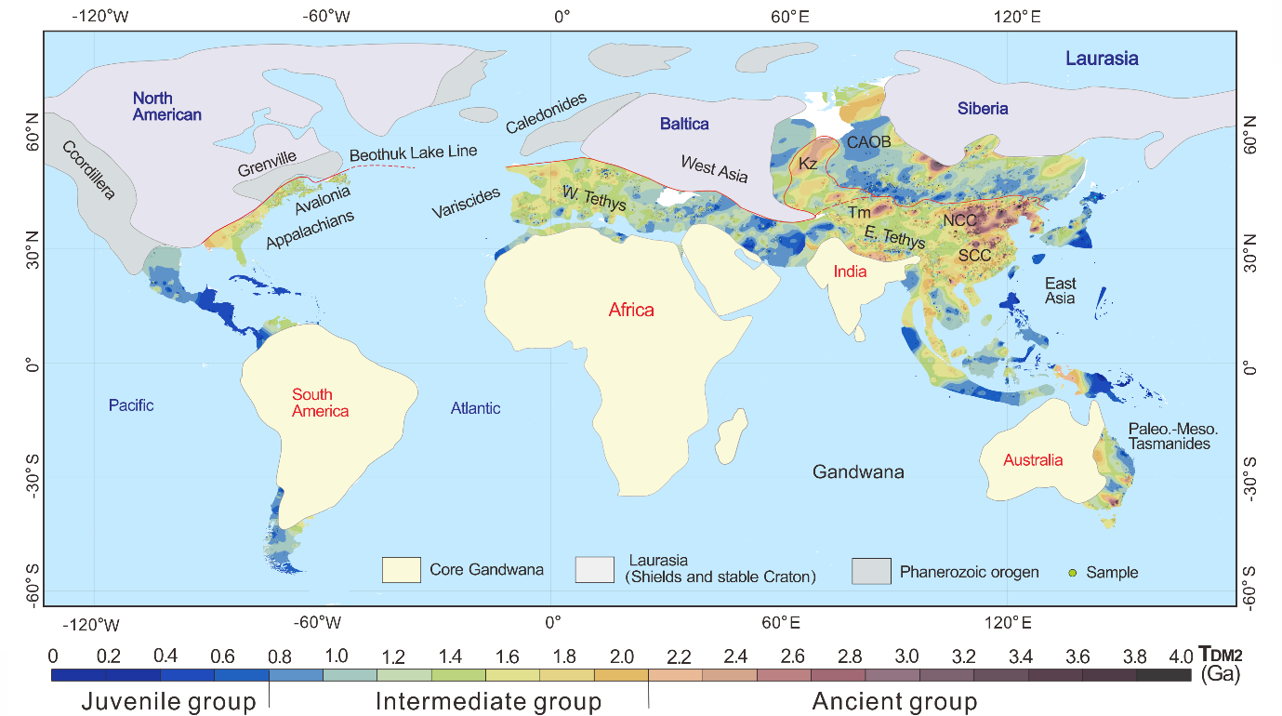
Collins explained the significance of the data: “The samarium-neodymium isotope maps that we’re looking at are not only a step back in time—they’re like a time machine—but they have this spatial character that allows us to recognize an ancient continental landmass that formed 500 million years ago, even though the mountains that the rocks are in are only 20 million years old.”
The link to the Cambrian explosion
The results show that Gondwana made up the vast majority of the continental landmass during the Cambrian period. This era featured the sudden appearance of large and complex life following billions of years of simple microbial organisms.
Almost all major animal families first emerged in this Cambrian “explosion” of life. This event set the stage for the incredible abundance and diversity of species that has inhabited our planet ever since.
The supercontinent was shaped by a “subduction girdle” of tectonic activity stretching across 79 percent of Earth’s circumference. The geological upheaval produced by these structures supercharged volcanic activity. This belched greenhouse gases into the atmosphere and warmed the planet from its previous “Snowball Earth” phase.
The combination of this warmer climate and an enrichment of new ingredients for life paved the way for the Cambrian explosion.
“This Ring of Fire that formed straight after Gondwana was a source of a huge amount of volcanic gasses, just like the volcanoes around the Circum-Pacific are today,” Collins said. “Those volcanic gasses—particularly water and [carbon dioxide]—are absolutely vital, for climate change, and also for biodiversity.”
What it means
In this way, planet-scale geological dynamics powered the lush biosphere that we still occupy today, as well as the 500-million-odd years of phantasmagorical ecosystems that preceded it. To reconstruct this process in even more detail, the team plans to expand their rock database and map out the remnants of this long-lost supercontinent with more precision.
“Maybe we can find other new directions, and solve other fundamental Earth science problems,” Wang concluded.